Click on the first image to view all photographs in 'Lightbox' (TM)
For a quick search whilst on this page press Ctrl +F (Windows) or Alt+F (Mac) and enter the street/place you are looking for.
Liverpool 12
Liverpool 13
Liverpool 12
 |
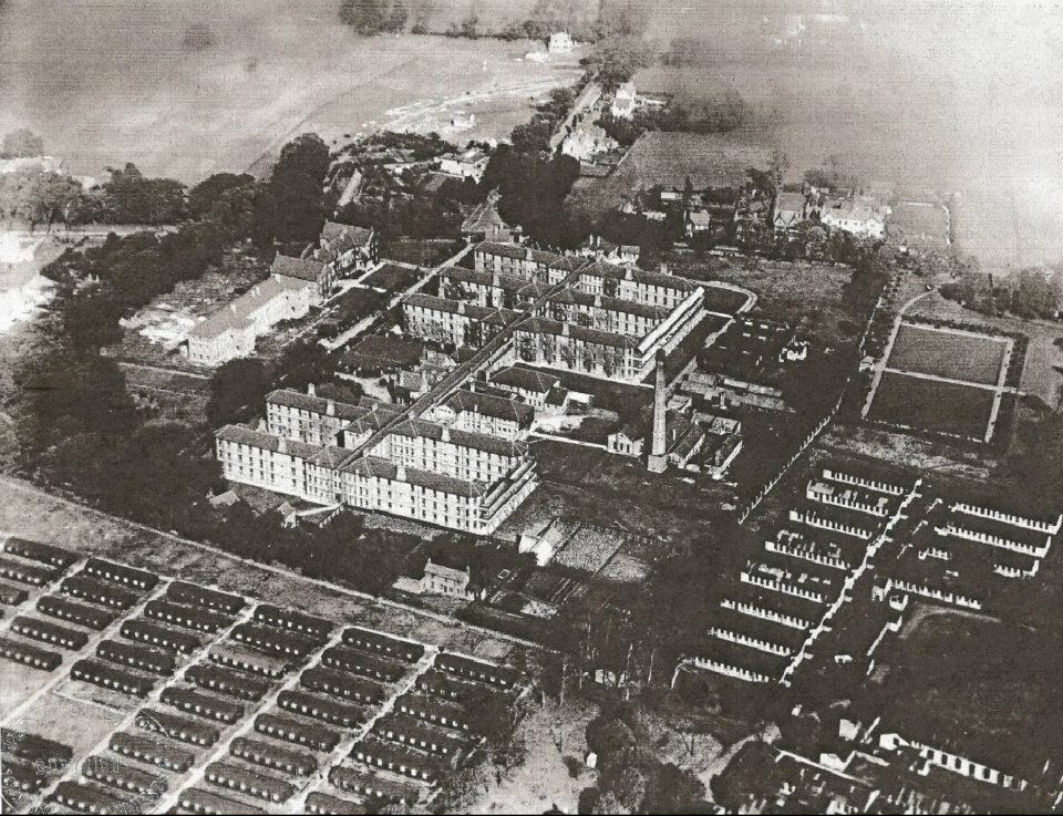
| Alder Hey Hospital on 07-03-1935 |
 |
| Alder Hey nurses room 1974 |
 |
| Alder Hey with U.S. Army huts on 07-09-1926 |
 |
| Almonds Green - part of the Norris Green estate - 1930 |
 |
| Almonds Green on part of the Norris Green estate - 1930 |
 |
| Blackmoor Drive - 1974 |
 |
| Blackmoor Drive housing office |
 |
| Blackmoor park CP assembly Hall. |
 |
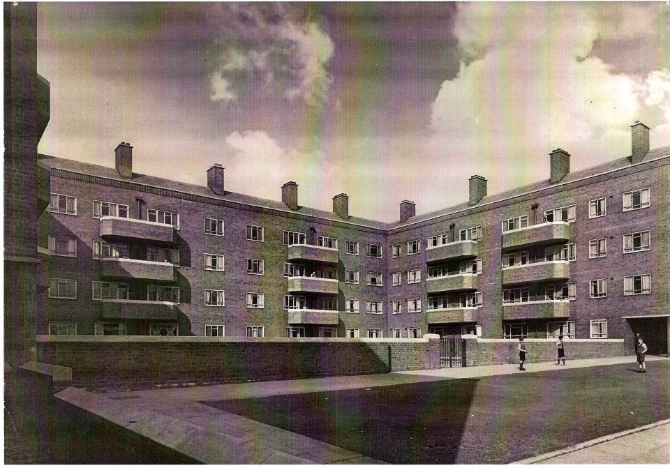
| Cantril Farm Estate Flats |
 |
| Cantril Farm Estate spreading out onto what was previously farmland |
 |
| Cantril Farm Estate. |
 |
| Cantril Farm Estate- |
 |
| Cantril Farm Estate... |
 |
| Cantril Farm Estate.. |
 |
| Cantril Farm Estate when new. Part of the estate around Feltwell Road and Mab Lane is in L12 but another part off Haswell Drive is L28. |
 |
| Cantril Farm Estate |
 |
| Cantril Farm Estate_ |
 |
| Cardinal Heenan (then Cardinal Allen) Honeysgreen Road |
 |
| Castlefield Road on the then new Norris Green estate in 1930 |
 |
| Croxteth Hall in 1919 |
 |
| Darley Drive at Eaton road on 18.8.75 |
 |
| Deysbrook Lane 15.5.56 |
 |
| Deysbrook Lane 68 - 72 12-11-58 |
 |
| Deysbrook Lane -15-05-56 |
 |
| Deysbrook Lane cottages 16-06-75.. |
 |
| Deysbrook Lane cottages 16-06-75 |
 |
| Deysbrook Lane Estate - July 1956 |
 |
| Deysbrook Lane on 20-11-1917 |
 |
| Dr Edwards house at 96 Deysbrook Lane 01.12.58 |
 |
| Eaton Gardens 10.6.74 |
 |
| Eaton road 10.4.75 |
 |
| Eaton road 18.8.75 |
 |
| Eaton road 121-125 at Norris Green road in 1975 |
 |
| Eaton Road 193-199a near Muirhead Avenue on 21.7.75 |
 |
| Eaton road 411-413 on 10.6.74 |
 |
| Eaton road 1975 |
 |
| Eaton road at Norris Green Road showing Nos 113-119 on 18.8.75 |
 |
| Eaton road DHSS at No 416 dated 10.6.74 |
 |
| Eaton road in 1975 from No.225 |
 |
| Eaton Road Nos 103-107 at Marfield road - 18.8.75 |
 |
| Eaton road police station in 1974 |
 |
| Eaton road, vets surgery on 10.6.74 |
 |
| Feltwell Road, part of the then new Canny Farm estate. |
 |
| Greenfield View off Deysbrook Lane on 12.11.58 |
 |
| Holly Lodge girls high school - 1975 |
 |
| Mab Lane |
 |
| Melwood House, Sandfield park east, elderley hostel. |
 |
| Mercer Place 5-7 showing a privy-midden on 12.11.58 |
 |
| Mercer Place off Deysbrook Lane 12.11.58 |
 |
| Mercer Place off Deysbrook Lane showing a bad living arrangement with the toilet off the bedroom. Something we'd call an en-suite these days. |
 |
| Mercer Place off Deysbrook Lane 12.11.58 |
 |
| Queens Drive at the Jolly Miller |
 |
| Sandfield Park school |
 |
| St Edwards College |
 |
| The Barracks, West Derby 1934 |
 |
| The Barracks, West Derby 1934 |
 |
| Norris Green road in 1906 |
 |
| The Jolly Miller bomb damage. |
 |
| The original Dog & Gun, Croxteth. |
 |
| Town Row 4-6 on 14-02-66 |
 |
| Town Row at Bonshall st in 1951 showing kids at L.E. Shillington's shop. |
 |
| West Derby train station 1966 |
 |
| West Derby train station in June 69 |
 |
| West Derby Village Hall 10.4.75 |
 |
| West Derby village Hall - Town Row on 10-04-75 |
 |
| A Goddess passes Hurst Gardens. |
 |
| A tram coming up St Oswalds street past the ropeworks on 4.9.52 |
 |
| Aberdale road 1935 |
 |
| Acathus Road |
 |
| Ardleigh road - wartime damage |
 |
| Atkinsons garage at No.1 Moscow Drive seen here from Green Lane on 21.8.67 |
 |
| Augusta st kitchen in 1965 |
 |
| Augusta Street interior in 1965 |
 |
| Bankfield Sec Mod boys school. |
 |
| Bibby Street Old Swan by Peterl Halligan in 1979 |
 |
| Binns Road, Edge Lane |
 |
| Borax Street in 1975 |
 |
| Brainerd st at Snaefell Avenue on 21.8.67 |
 |
| Brainerd street air raid shelter - 1940 |
 |
| Brainerd Street from Green Lane on 21.8.67 |
 |
| Broadgreen Road 11.02.1905 |
 |
| Broadgreen Road 19-27 on 1.4.74 |
 |
| Broadgreen Road 27.10.1912 |
 |
| Broadgreen Road 38-48 in 1968 |
 |
| Broadgreen Road garage near Oakhill Park 1.4.74 |
 |
| Broadgreen Road near the Rocket on 13.09.1928 |
 |
| Broadgreen Road Silvernia stores 1934. |
 |
| Broadgreen Road Silvernia Stores 1934 |
 |
| Corporation offices at 72 Gren Lane on 21.8.67 |
 |
| Crawfords biscuit factory, Binns road. |
 |
| Croft road in 1955. A milk trailer. Pic by Harry Pope |
 |
| Cromarty Road 1924 |
 |
| Derby Lane Old Swan on 20.7.60 |
 |
| Derby Lane-Prescot road. |
 |
| Derby street Old Swan in 1966 |
 |
| Derby Street scullery in 1966 |
 |
| East Prescot rd with Lister Drive power station in the distance. |
 |
| East Prescot road flood in 1976. This pic was taken near the Lord Nelson pub. |
 |
| East Prescot Road looking across Broadgreen road in 1957 |
 |
| East Prescot road, Old Swan end |
 |
| Edge Lane 1912 |
 |
| Edge Lane from Binns Road in 1962 |
 |
| Edge Lane Hall. |
 |
| Edge Lane Lucas factory |
 |
| Elms House construction in the 1920s |
 |
| Elms House estate construction in the 1920s |
 |
| Elms House Estate construction in the 1920s showing Davidson Road |
 |
| Empress Road gypsy caravans 1927 |
 |
| Fitzgerald road on the corner with Ravenswood road showing a shop conversion from a house on 24.4.1936 |
 |
| Green Lane 1906 |
 |
| Green Lane bus depot in 1956 |
 |
| Green Lane from Moscow Drive on 21.8.67 |
 |
| Green Lane from the air |
 |
| Green Lane stables 2nd Dec 1927 |
 |
| Green Lane tram sheds in 1902. These actually fronted onto Prescot Road. |
 |
| Green Lane, Old Swan |
 |
| Hoults corner 1937 |
 |
| Hoults corner demolition. |
 |
| Hoults Corner. St Oswalds House tenements are now up and road widening will soon happen which sees Hoults corner bite the dust. |
 |
| Hurst Gardens |
 |
| Knoclaid Rd |
 |
| Knoclaid Road 103-113 at Londonderry Rd on 9.1.73 |
 |
| Larkhill flats, Muirhead Avenue. |
 |
| Larkhill flats, Muirhead Avenue. |
 |
| Lisburn Lane 153-161 on 9.1.73 |
 |
| Lisburn Lane at Craigs Road on 9.1.73 |
 |
| Lisburn Lane in 1975 |
 |
| Lisburn Lane showing a house conversion to a shop in April 1936. |
 |
| Lister Drive allotments looking towards the rear of the Seaman's Orphanage in Newsham Park on 21.8.67 |
 |
| Lister Drive at Green Lane on 21.8.67 |
 |
| Lister drive baths, now a fisheries. |
 |
| Lister Drive County Primary on 21.08.1967 |
 |
| Lister Drive from Green Lane on 21.8.67 |
 |
| Lister drive power station chimneys |
 |
| Lister Drive power station. The 4 chimneys were known as Mathew, Mark, Luke and John, the very same names bestowed upon the 4 bells outside the Metropolitan cathedral. |
 |
| Maiden Lane - 18th Aug 75 |
 |
| Meccano factory- |
 |
| Meccano factory- |
 |
| Meccano factory- |
 |
| Meccano factory- |
 |
| Mill Lane 1975 |
 |
| Mill Lane - Robinson Willey - 1975 |
 |
| Mill Lane bomb damage 30.8.1940 |
 |
| Millbank 1952 |
 |
| Moscow Drive looking east from Green Lane on 21.6.71 |
 |
| Muirhead avenue 1921 |
 |
| Muirhead avenue 1925 |
 |
| Muirhead Avenue Larkhill Lane 1954 |
 |
| New Road looking North towards West Derby road on 21.8.67 |
 |
| New Road near West Derby Road 21.8.67 |
 |
| New Road on 21.8.67 |
 |
| Oakhill Road from Broadgreen rd on 1.4.74 |
 |
| Old Swan glassworks. The Glass house pub now stands near this site, named in its commemoration. |
 |
| Old swan rope works site on 2.6.65 |
 |
| Old Swan tech college old building just before its demolition in Nov 74. You can see the 60s replacement college further down the road, now itself only a distant memory. |
 |
| Old Swan tech old building entrance. Demolished Nov 74 |
 |
| Old Swan technical college, Broadgreen rd 1974. It would be demolished in November of this same year. |
 |
| Old Swan Water Tower |
 |
| Pemberton Road 56-58 (2) |
 |
| Pemberton Road 56-58 |
 |
| Prescot rd 5th June 68 |
 |
| Prescot rd 1953 |
 |
| Prescot rd 1956. Photo by Eric James |
 |
| Prescot rd by Peter Halligan. |
 |
| Prescot rd by Peter Halligan |
 |
| Prescot rd tram 1954 |
 |
| Prescot rd tram -4th June 54 |
 |
| Prescot road |
 |
| Prescot Road at Blackhorse Lane in 1925 |
 |
| Prescot Road at Blackhorse Lane on 3.4.1933 |
 |
| Prescot Road at Green lane showing road repairs |
 |
| Prescot road at Rawlins street |
 |
| Prescot road by Peter Halligan |
 |
| Prescot Road from Blackhorse Lane on 21.10.1936 |
 |
| Prescot road from Green Lane |
 |
| Prescot road in 1968 from the heights. |
 |
| Prescot road near the Cygnet Derby Lane in 1947 |
 |
| Prescot road old cattlemarket 1923 |
 |
| Prescot road showing the site of the Curzon cinema in 1935 |
 |
| Prescot Road towards Green Lane c1914 |
 |
| Rathbone rd between Witton Grove and Binns Road in 1976 |
 |
| Rathbone rd between Witton Grove and Binns Road in 1976 |
 |
| Rathbone Road - Ventner road Lodge - 5.3.56 |
 |
| Rathbone road at Long Lane 1975 |
 |
| Rathbone road at Oceanic Road 1975 |
 |
| Rathbone road East side in 1976 |
 |
| Rathbone Road in 1975 between Sapphire st and Binns Rd |
 |
| Rathbone road tram 1956 |
 |
| Robinson Willey, Mill Lane, Old Swan |
 |
| Rocky Lane, Old Swan April 1936. |
 |
| Roscoe Primary - 1973 |
 |
| Russian Drive showing a shop conversion on 24th April 1936 |
 |
| Snaefell Avenue at Brainerd st on 21.8.67 |
 |
| Snaefell Avenue at Sutton Street on 21.8.67 |
 |
| St Matthews Church, Clubmoor in 1927 |
 |
| St Oswald House 1948 |
 |
| St Oswald House from the rear in 1948 |
 |
| St Oswald House in the 1950s. |
 |
| St Oswald House tenements in May 1948 |
 |
| St Oswald House. |
 |
| St Oswald House. |
 |
| St Oswald st flats. |
 |
| St Oswald street flats - St Oswald House. |
 |
| St Oswald street side of Hoults corner in 1937 |
 |
| St Oswald tennies demolition |
 |
| St Oswald's curve - 1973 |
 |
| St Oswalds street |
 |
| St Oswalds new school - 1979 |
 |
| St Oswalds old school 1.4.74 |
 |
| St Oswalds school. |
 |
| St Oswalds street 24-32 in 1937 |
 |
| St Oswalds street at Hoults corner |
 |
| St Oswalds street c1906 |
 |
| St Oswalds street old and new on 12.06.1939 |
 |
| St Oswalds street potato market in 1937 |
 |
| St Oswalds street Rock house and engineering works in 1937 |
 |
| St Oswalds street ropework from Victoria Place looking north on 8.12.1937 |
 |
| St Oswalds street towards Prescot road in 1957 |
 |
| St Oswalds street yards of 16-18 in 1937 |
 |
| St. Oswalds street 01.07.1950 |
 |
| St Oswald's Street - Old Swan L13 |
 |
| St Oswalds tennies in 1948.. |
 |
| St Oswalds tennies in 1948. |
 |
| St Oswalds tennies in 1948 |
 |
| St Oswalds tennies in May 48 |
 |
| St Oswalds. Montague Street 1.4.74 |
 |
| St Oswalds new school - 1979 |
 |
| Stanley abattoir 1958 |
 |
| Stanley Abattoir in 1959 |
 |
| Stanley Abattoir |
 |
| Stanley cattle market 1923. |
 |
| The Carlton Cinema, Green Lane. |
 |
| The Cattle Market at 329 Prescot Road, Old Swan on 3.8.70 |
 |
| The Cattle Market Inn, Stanley. |
 |
| The Clubmoor picture house which opened in 1925 |
 |
| The Coconut Grove.. |
 |
| The Coconut Grove. |
 |
| The familiar curve of St Oswald House flats. |
 |
| The Farmers Arms, Lark hill lane 1927 |
 |
| The Gardeners Arms 23.3.25 with its replacement being built behind. |
 |
| The Green and Broadgreen Hospital 1972 |
 |
| The lanmark curve of St Oswald House tennies with shops below. A huge Tesco now stands here. |
 |
| Add caption |
 |
| The Masons Arms by Brian Saville |
 |
| The Masons Arms |
 |
| The Meccano factory showing graffiti from after the industrial action regarding its closure. |
 |
| The Gardeners Arms 23.3.25 with its replacement being built behind. |
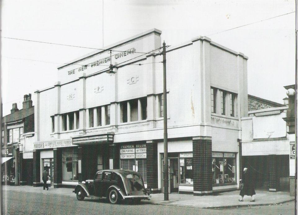 |
| The New Premier cinema, old swan. |
 |
| The Original Gardeners Arms 1.2.25 with its replacement being built behind. |
 |
| The Original Gardeners Arms 1.2.25. |
 |
| The Original Gardeners Arms, Broadgreen Road with Fairview cottages which faced a huge nursery, hence the name of them. |
 |
| The Premier cinema. |
 |
| The rear of St Oswald House. |
 |
| The Rocket pedestrian walkways as captured by Derek Hyamson. |
 |
| The Rocket pedestrian walkways as captured by Derek Hyamson. |
 |
| The Royal Standard at St Oswalds street-Rock st in 1937 |
 |
| The Stanley in the 1920s |
 |
| This one time Co-Op on Queens Drive with Prescot Road has spent recent years as Garfields pub and then a Wetherspoons. |
 |
| Tuebrook Police station demolition for the widening of West Derby Road |
 |
| Tuebrook police station which was flattened for the widening of West Derby road. A new one now stands nearby. |
 |
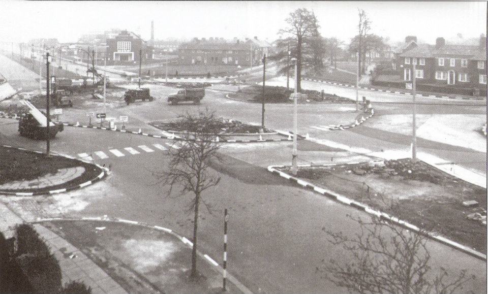
| Tuebrook roundabout 24.5.60 |
 |
| Tuebrook Roundabout 1960 looking towards West Derby rd |
 |
| Tuebrook shelter damage. |
 |
| Waste land off Pighue lane with a gypsy caravan on site. |
 |
| West Derby Comp - 1957 |
 |
| West Derby Comp - Quarry Road. |
 |
| West Derby Junior school. |
 |
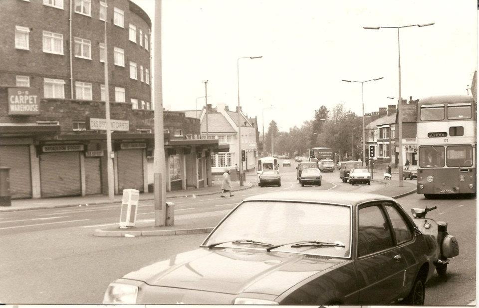
| West Derby rd 541-555 at Buckingham rd on 9.1.73 |
 |
| West Derby rd 1949 |
 |
| West Derby rd 1955 |
 |
| West Derby road 1960. Tuebrook roundabout showing Muirehead Avenue flats |
 |
| West Derby Road - Coburg Terrace |
 |
| West Derby Road showing the old Tuebrook police station on the right. |
 |
| West Derby Road c1950s |
 |
| West Derby Road from Gloucester road showing the dual carriageway construction and widening of the road. 21.08.67 |
 |
| West Derby Road from Snaefell Avenue - 21.08.67 |
 |
| West Derby Road from Somerset Place near Trinity Methodist church on 21.8.67 |
 |
| West Derby road on 21st Aug 67 from Ivy Leigh. |
 |
| West Derby Road. 615-637 Liverpool 14 
Bowring Park road bridge construction in March 1966

Broadgreen Hospital maternity ward

Chatterton Road Knotty Ash camp on 28.07.26
Constructing the roundabout in Dovecot at the Greyhound.

Dovecot Place shops in 1933 with the steelwork up
for the construction of the Granada Cinema.

Dovecot Place shops when new in 1933

Facing the Rocket Inn

Finch house estate shops in 1935

Grovehurst Avenue 20th July 1933

Grovehurst Avenue

Highfield House in 1900

Highfield military hospital nurses home, later Broadgreen hospital.

Huts at Knotty Ash in 1920

Pilch Lane Co-op. Pic by Harry Pope.

Knotty Ash brewery and pub 1904

Knotty Ash brewery, East Prescot Road.

Knotty Ash camp 1919

Knotty Ash primary 1974.

Knotty Ash primary 1974

Knotty Ash station in 1966

M62 Construction..

M62 Construction..

M62 Construction..

St. Margaret Mary's - 1975
|
 |
| The Harold Davies baths interior in 1958 |
 |
| The Rocket area - 1938 |
.jpg) |
| The Rocket area 1938 (2) |
 |
| Thomas Lane |